


Zoltán Kiss- Area Sales Manager - East Europe - Endrich GmbH.
GNSS (Global Navigation Satellite system) receivers
8 September 2013

Summary :
Global navigation is becoming more and more standard in the traffic, cars are equipped with ex-factory or aftermarket receivers, aircrafts, ships and boats are using GNSS to navigate and also the precision agriculture requires this technology to navigate the heavy equipments like harvesters in order to define the yield map of the area being harvested. GNSS is the generic name of SAT based navigation systems that are providing autonomous geo-spatial positioning. There are number of networks that use their own satellites in combination with the associated earth stations in order to transmit correct positioning and timing data. All these systems that are global are collected under the name of GNSS. We would like to shortly show them in this article as well as some special devices, that could be used in receiver applications, like smart antennas, complete GNSS/TMC modules and receivers, being able to use the advantage of interoperability between different systems in order to maximize the performance of the navigation.
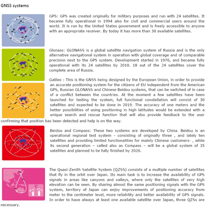
GNSS systems
GNSS modules (concurrent multi-GNSS receiving)
The performance of the SAT navigation systems is defined by the following four criteria:
Accuracy: The desired minimal difference of the real position, speed and direction of the object and the geo-position measured by the receiver
Integrity: The capability of the system to provide confidence in signaling system abnormalities
Continuity: the system’s ability to perform without interruptions
Availability: Maximum time during the signal meets the criteria of accuracy, integrity and continuity
Availability: Maximum time during the signal meets the criteria of accuracy, integrity and continuity In order to get the best performance of the signals it is not enough only to see four satellites, that was enough to get usable coordinates, but need six or even eight ones. It is not always possible to get eight satellites in view in certain part of the day, especially in environment with disturbing objects like high buildings, trees and hills. The integration of different systems would provide the advantage of using many more satellites, like for instance the combined usage of GPS and GLONASS systems provide access to more satellites, than GPS alone. The 24 GPS satellites are extended with the GLONASS ones, which results more precise functioning, especially when the receiver is used in higher latitudes, where some of the GPS satellites are below the horizon of the observer, therefore even less would be available at the same time. The so called GNSS receivers can detect signals of combinations of global positioning satellite systems, like GPS, GLONASS and later on GALILEO in order to shorten the time of the first fix (TTFF) of position and provide more accuracy. For above purposes Endrich offers a number of GNSS receiver modules from our supplier LOCOSYS, a TS16949:2009 approved innovator and leader of the GNSS market, engaged to the quality of the products.
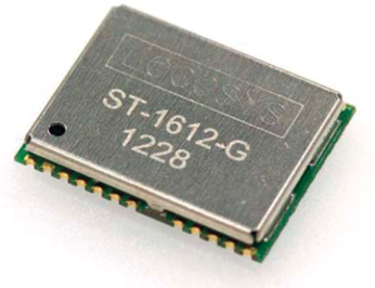
Locosys, the partner of Endrich offers a number of receiver modules for the detailed GNSS systems, which could be used for instance for mobile alarm systems of cars, boats, motorcycles, week-end houses as well as track and trace devices for human , animal and cargo tracking applications. The chipsets being used are from Mediatek, CSR (SIRF) and STM. Mediatek chips support concurrent multi-GNSS receiving including GPS, GLONASS, Beidou, Galileo, QZSS as well as SiRFstarV chips. The result is high availability and accuracy for positioning and navigation outdoors or on pedestrian areas. STMicro chips are used for more enhanced systems, like automotive market having the appropriate AECQ100 approvals. The firmwares are programmed in house, therefore software platform and programming environment are available for all modules. For cheaper applications with less requirements ROM based firmwares could be used, for more complex tasks -like for advanced GPS functions - Flash memories are used. Customization of the antenna into customers application is possible.
GNSS smart antennas
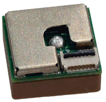
The GNSS smart antennas include a board level GNSS receiver and an embedded GNSS patch antenna integrated into one compact enclosure. The product, that Locosys offers is based on MediaTek chip solution. The GPS smart antenna will acquire up to 66 satellites at a time while providing fast time-to-first-fix, one-second navigation update and low power consumption. It can provide user with superior sensitivity and performance even in urban canyon and dense foliage environment. Its far-reaching capability meets the sensitivity requirements of car navigation as well as other location-based applications.
GPS timing
In addition to positioning data, the GPS provides a very important dimension, the time. Each of the satellites contains atomic clocks that insert precise time data to the GPS signals. GPS receivers decode these signals, and synchronize themselves. Instead of operating expensive atomic clocks, this feature enables users to determine the time very precisely. Precise time is very important to a large number of tasks in parctise. Communication systems, traffic signals, electrical power grids, and financial networks all rely on precision timing for synchronization. The availability of GPS time provides a cost effective way for engineers to realize time base for computer network applications, time stamp for bank card transactions or synchronizing radio broadcast. Weather forecasting, distributed networks of instruments over wide geographic areas all need precise timing for perfect functioning. Power plants and distribution companies need improved time synchronization throughout the power grid in order to locate the anomalies propagate through the network segments. We can also provide solution with the Locosys timing module with the physical size of 16 x 12.2 x 2.2 mm equipped by UART/CAN BUS/USB interface.
TMC Module
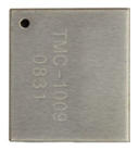
The LOCOSYS TMC-1009 RDS tiny module is designed to allow easy integration of TMC (Traffic Message Channel) functionality in customer portable devices or mobile navigation systems. TMC-1009 can receive and decode the TMC information efficiently and output the data with AdvanceTMC protocol which is NMEA-like ASCII message and downward compatible with OpenTMC v2.0.
| Share on Facebook | Share on LinkedIn |
References
This article has been published on the following locations:
| # | Media | Link |
|---|---|---|
| 1 | Elektronet 2013/5 | Elektronet : elektronikai informatikai szakfolyóirat, 2013. (22. évf.) 5. sz. 31-32. old. |
| 2 | Hungarian version | GNSS (Global Navigation Satellite System) vevő egységek az Endrich kínálatában |
| 3 | TechStory M2M | GNSS vevő egységek az Endrich kínálatában |
| 4 | South-East European Industrial Market 2017/3 | Issue 3/2017 page3 |
| 5 | New Technology online | GNSS (Global Navigation Satellite System) vevő egységek és használatuk |
| 6 | New Technology 2019/3 | 2019. 3.sz. 36-39.o. |